


ENVIRONMENT NEWS - Following the devastating storm that ravaged the Western Cape between 10 and 12 May 2026, the South African Weather Service (Saws) can confirm that exceptionally high rainfall totals have been recorded at the Ceres Automatic Weather Station (AWS), highlighting a notably active start to the winter rainfall season over parts of the southwestern interior in the province.
Rainfall observations extracted on 22 May indicate that the Ceres AWS has already accumulated a monthly total of 507mm for May to date. This amount far exceeds rainfall totals recorded during the preceding months of 2026.
The most significant rainfall event occurred between 10 and 12 May, when two persistent and intense cold fronts affected Ceres and much of the Western Cape.
During this three-day period, the station recorded:
- 69.4mm on 10 May
- an exceptional 333.2mm on 11 May
- 75.6mm on 12 May
Rainfall comparison against long-term monthly averages
The May 2026 rainfall total recorded at the Ceres AWS was exceptionally high when compared with the station’s long-term climatological monthly averages.
The station recorded 507mm during May 2026 (to date), while the long-term average rainfall for May is about 80.4mm. This means that the rainfall during May was more than six times the average monthly rainfall normally expected for this time of year.
The rainfall total also exceeded the climatological monthly averages for the peak winter rainfall months, including:
- June average: 245.2mm
- July average: 182mm
- August average: 120mm
Climatologically, May marks the transition into the Western Cape winter rainfall season.
However, the magnitude of rainfall observed during May 2026 was significantly above normal.
While the substantial rainfall contributed positively to dam levels, groundwater recharge, river flows and agricultural water availability, the excessive rainfall over this short period led to adverse impacts on communities.
Much of the impact associated with these extraordinary rainfall amounts was experienced across the Witzenberg, Breede Valley and Langeberg municipalities, largely due to the Breede River catchment system originating in the Skurweberg Mountains near Ceres.
The river flows through Mitchell’s Pass into the Breede River Valley and continues through major agricultural and wine-producing towns such as Worcester, Robertson and Swellendam before reaching the Indian Ocean at its estuary in Witsand. As a result, heavy run-off and rising river levels contributed to widespread impacts across parts of the catchment.
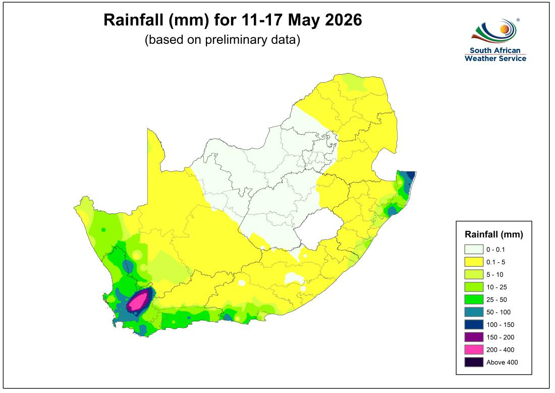 Figure 1: Preliminary accumulated rainfall totals across South Africa for the period 11-17 May 2026 over parts of the southwestern Western Cape, including Ceres.
As illustrated in Figure 1, the highest accumulated rainfall totals for 11 to 17 May 2026 were concentrated over parts of the southwestern Western Cape, particularly around the Ceres region and adjacent mountain catchment areas.
Rainfall amounts are in the range of 200 to 400mm over the 10-day period.
This one-of-a-kind rainfall event preliminary points to a 1:200 rain return (once every 200 years) or potentially a substantially rarer event requiring a detailed statistical analysis.
Compiled by Robin-Lee Batties, client liaison officer, Western & Northern Cape.
‘We bring you the latest Garden Route, Hessequa, Karoo news’


